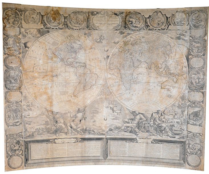
BOCQUET, Nicolas
NOLIN, Jean-Baptiste Le Globe terrestre representé en deux plans-hémisphères sur la projection de Mr. de la Hyre [...] et sur plusieurs routiers et mémoires des plus habiles pilotes et savans voyageurs le tout rectifié et calculé selon les dernieres observations [...]. Paris Crépy 1775 12 copper engravings mounted on hardboard with a total size of 121,4 x 151 cm (partially browned, dampstains, marginal notes, twisted! board and slightly used). An outstanding wall map based on 4 central sheets, plus borders, "one of the finest large-scale world maps to be produced and a fitting bridge between the geographical and artistic skills of the seventeenth century and the century to come", in a later state by Jean-Baptiste Crépy (1st ed. : 1700). Geographically, the map beautifully features the knowledge gained from recent discoveries, as well as prevailing cartographic misconceptions, such as the mythical Strait of Anián, the Great Western Sea in Northern California, the eastern coast of Australia enigmatically delineated etc. To emphasize the connection between geography and history, both hemispheres are carried by 4 atlas figures and are represented in front of 6 biblical scenes from Genesis, including an allegoric Ptolemaic conception of the universe, while the decorative borders of the map show 22 scenes from biblical history untill the Deluge, all by Bocquet. Since parlour maps were especially prone to damage, their survival rate is very low turning every piece into a unique rarity. Ref. Shirley, 605.